 NMU Receives Grant for Lake Superior Weather and Wave Buoys
Northern is leading a collaborative effort to establish a coastal hazard observing system for a stretch of Lake Superior shoreline that includes the communities of Marquette, Munising and Grand Marais. The project is funded by a $100,000 grant from the Great Lakes Observing System.
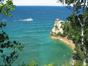
As part of the system, project scientists will deploy two monitoring buoys on Lake Superior. One will be placed near Munising within five nautical miles of Pictured Rocks National Lakeshore. It will provide minute-by-minute observations of weather, water temperature and wave activity to boaters and kayakers. A second, more portable buoy will provide measurements of wave activity along various stretches of the Lake Superior shoreline, including Granite Island Light Station, Grand Marais and Whitefish Point.
“It’s been a problem for the National Weather Service to predict storms because there’s currently not much in the way of consistent monitoring along that stretch of shoreline,” said Norma Froelich (Earth, Environmental and Geographical Sciences). “The hope is that this will allow for greater preparedness for coastal weather events, which will benefit the Coast Guard and fire departments for rescue purposes, as well as fisheries and recreational businesses that depend on the lake. It will also provide more advance warning of swimming and boating hazards, since waves tend to build up offshore first.”
The equipment will be in position from May through November each season. Froelich said data from the system will be provided in real time to a public website and various agency and community stakeholders. The Superior Watershed Partnership (SWP) is also developing a mobile app. The third project partner joining NMU and SWP is LimnoTech, an environmental consulting company based out of Ann Arbor that has previous experience with buoy and weather station deployments on the Great Lakes, including the system that is currently on Granite Island.
 “We will be engaging the communities through public forums to provide education and outreach materials and to help them productively use and disseminate the data,” Froelich said. “We will also put up interpretive displays at Miner’s Castle, the Great Lakes Shipwreck Museum and in Munising and Marquette to let people know about the monitoring taking place, inform them about wave conditions and direct them to the related website and app.”
Two community forums are scheduled: one at 7 p.m. Sunday, Nov. 30, at the Ore Dock Brewing Company in Marquette; and one at 7 p.m. Wednesday, Dec. 3, at Falling Rock Café in Munising. Collaborators will share information about the new system and gather input from each community.
Before the grant proposal was written, NMU, SWP and LimnoTech received input and feedback from numerous individuals and organizations, including the National Weather Service office in Negaunee Township, U.S. Coast Guard, Pictured Rocks National Lakeshore and the Cities of Marquette and Munising.
“We’re very grateful for the feedback and interest we’ve received from all of our local stakeholders,” says John Lenters, a senior scientist at LimnoTech. “And we’re looking forward to continued input from these groups and the general public as we work toward buoy deployment in the spring of 2015. Our hope is that the data will be of use to a lot of people along the southeastern shore of Lake Superior.”
Froelich said NMU students will be involved in data analysis, exploring how wind and waves are related to weather conditions in different seasons.
NMU alumnus and trustee Scott Holman owns Granite Island Light Station, where one of the wave sensors will be located. The station has been put to productive use for previous research projects and helps to relay NMU’s WiMAX signal to deliver high-speed Internet to Powell Township School in Big Bay. It is located about 10 miles offshore of Marquette.